Références

« Working together and joining our resources, we can accomplish great things. »

Ronald Reagan, American actor and president

River Dranse de Bagnes

Key-words:

River engineering, Flood protection, Sediment management, Restoration
Natural hazards and risks, Alarm planning

Date:

2011-2016

Client:

Communities of Sembrancher and Vollèges

Partners:

CERT ingénierie sa (project management), Droséra SA, Tissières SA et Jean-Louis Boillat

Achievements:

Project and detailed project
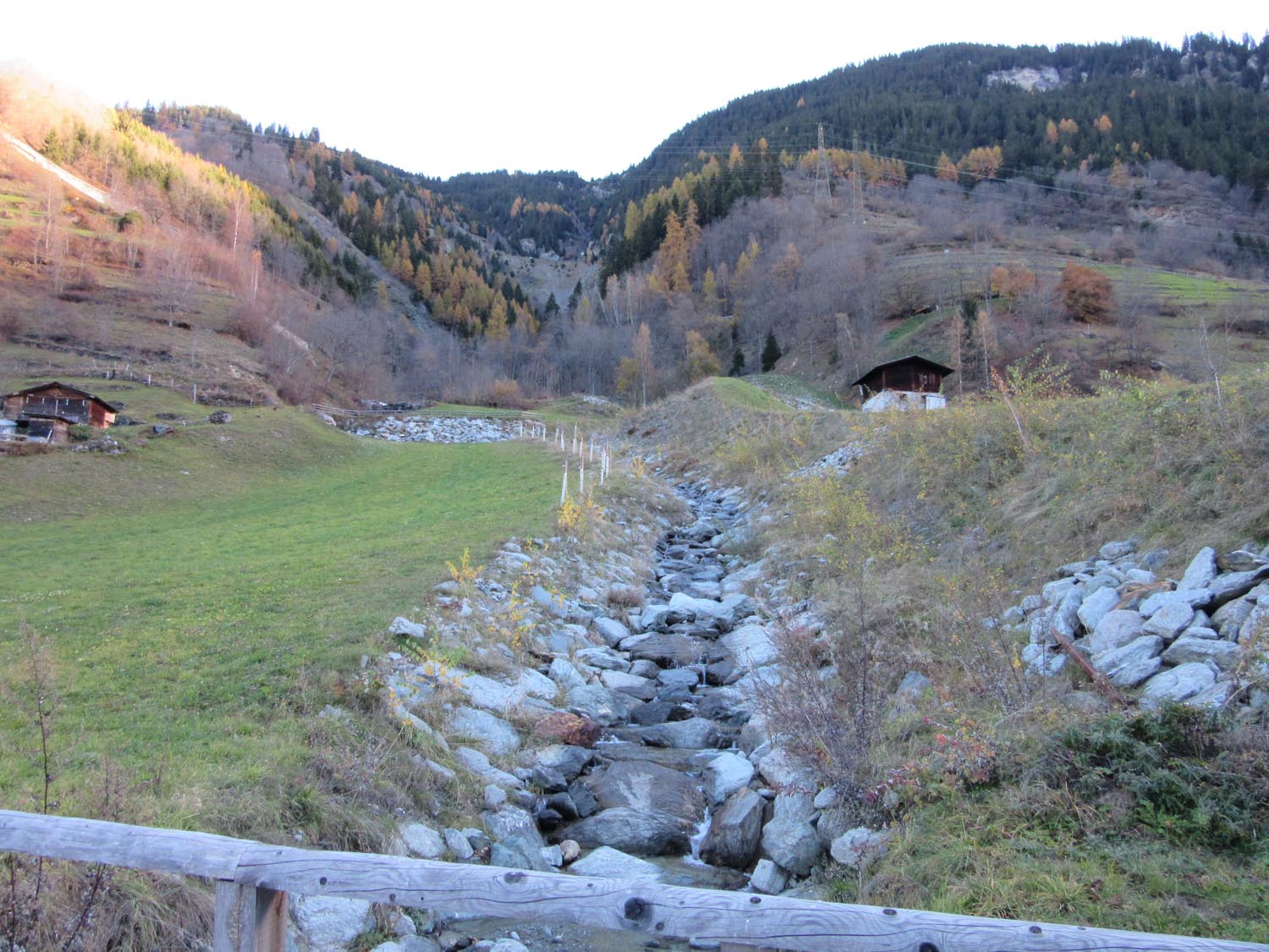
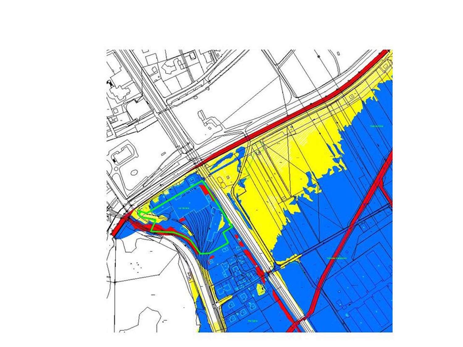
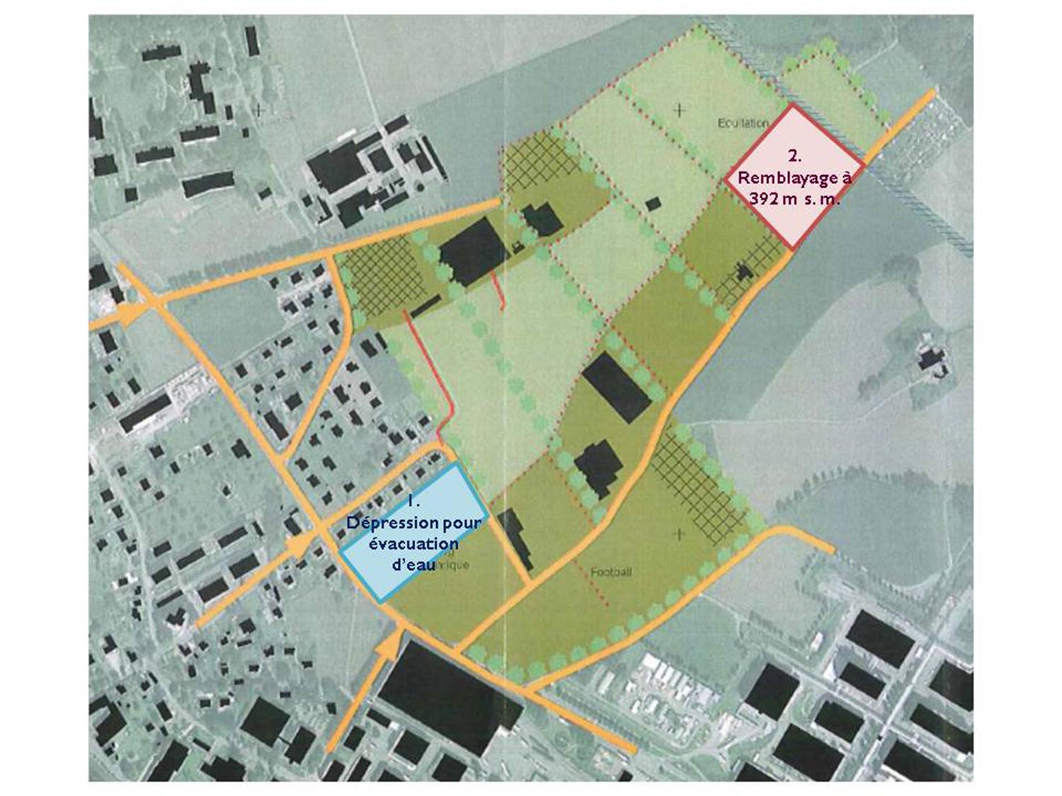
Restorations- und Flood protection measures.
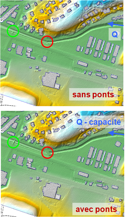
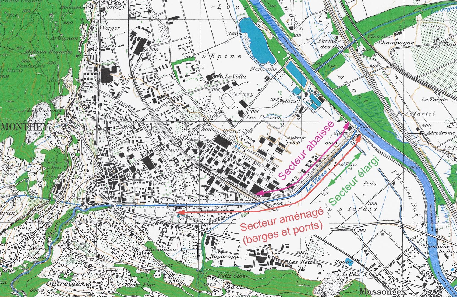
Hydraulic computation with and without sediments transport. Design of a widening, groins, deflectors, bank protection and structures for gravel plants.
Design of levees and bridges.
Alarm planning before, during and after construction of the mitigation and restoration measures.

EXAR

Key-words:

Natural hazards and risk, Hazard map

Date:

2014-2015

Client:

FOEN, Federal office for the environment of Switzerland

Partners:

Emch+Berger Bern AG, Geo 7

Achievements:

Preliminary study
Methodology for studying the consequences of very rare floods of the rivers Aare and Rhine.
Choice of hydrological methods, taking into account failure of hydro power facilities or levees, sediment and drift wood transport.

Alarm planning for the village of Verbier

Key-words:

Natural hazard and risk, Alarm and emergency planning

Date:

2008-2012

Client:

Community of Bagnes

Partners:

CERT ingénierie sa (Project management)

Achievements:

Preliminary study
Definition of threshold values for rain intensity and discharge.
Evaluation of outflow points and points for intervention as well as planning of the emergency measures in collaboration with the fire brigade.
Preparation of intervention instructions.

Flood hazard map of the torrents of Verbier

Key-words:

Natural hazards and risk, hazard map

Date:

2006-2016

Client:

Commuity of Bagnes

Achievements:

Preliminary study
Simulation of the flooding of the torrents of Verbier with a high definition two-dimensional model. Analysis of the influence of bridge blockage.
Supperposition of the over hundred scenarios for the hazard map, dossier for approval.

Natural hazard map of the Wental

Key-words:

Natural hazards and risk, hazard map

Date:

2013-2015

Client:

AWEL, Amt für Abfall, Wasser, Energie und Luft, Zürich

Partners:

Emch+Berger Bern AG (Project management)

Achievements:

Preliminary study
Analysis of the hydraulic capacity of the river Surb with a one-dimensional HEC-RAS-model. Evaluation of the blockage probability of the bridges according to Schmocker&Hager.
Simulation of the flooding of the river Surb and its tributaries with a two-dimensional hydraulic model.

Hall of St-Marc

Key-words:

Natural hazards and risk, Risk assessment

Date:

2011

Client:

Community of Bagnes

Achievements:

Preliminary study
Hazard and risk assessment based on the hazard map of the river Dranse de Bagnes.
Delimitation of space provided to water.
Structural measures as air supply and light wells above water level, displacement of building access in safe areas and a dam along the river.

Reservoir Chaudron

Key-words:

Natural hazards and risk, Hazard map

Date:

2013

Client:

Télé Champéry-Crosets Portes du Soleil SA

Achievements:

Preliminary study
Computing the maximal discharge due to dam break according to CETEGREF and computing the hydrograph with a two-dimensional model of the reservoir.
Propagation of the discharge through the valley of the Chevalet torrent towards the river Vièze using a two-dimensional model.
Flood maps and report for the authorities who have to decide if the dam has to be submit to an official control plan.

River Vièze in Monthey

Key-words:

River engineering, Flood protection, Sediment management, Restoration, Space provided to water, Hazard map
 

Date:

2004-ongoing

Client:

City and community of Monthey

Partners:

CERT ingénierie sa (project management), françois-xavier marquis sàrl, BEB SA, dv architectes, Jean-Louis Boillat

Achievements:

Preliminary study, preliminary design project und petailed project
Analysis of hydraulic capacity and weak points. Elaboration of different variants.
Definition of the design flood based on a cost-benefit analysis.
optimisation of the profile considering sediment transport, restoration measures and freeboard.
Hazard assessment „after measures“ using a 2D-model.
Release of the space provided to wateres.

Flood protection on the torrent Fregnolay

Key-words:

River engineering, Flood protection, Restoration
Natural hazards and risks, Alarm planning

Date:

2009-2010

Client:

Community of Bagnes

Partners:

CERT ingénierie sa (Project management), Drosera SA

Achievements:

Preliminary design project und construction project
Restoration and protection measures on the torrent with debris flow.
Hydraulic computation and modeling of debris flows.
Design of structures as levees.
Concept for revegetation of the banks.
Establishment of an alarm planning.

Natural hazard map of the city of Moutier

Key-words:

Natural hazards and risk, Hazard map

Date:

2013-2014

Client:

Community of Moutier

Partners:

Emch+Berger Bern AG (Project management), Institut Géotechnique SA

Achievements:

Preliminary study
Analysis of the hydraulic capacity of the rivers Birs and Raus with a one-dimensional HEC-RAS-model.
Simulation of the flooding of the rivers with a two-dimensional hydraulic model.

Flood hazard map of the river Dranse de Bagnes

Key-words:

Natural hazards and risk, Hazard map

Date:

2009

Client:

Community of Bagnes

Achievements:

Preliminary study
Hydrological analysis for evaluating the flood peak discharges taking into account the flood routing in the Mauvoisin reservoir.
Two-dimensional model of the river Dranse and simulation of the floods.
Definition of a criterion for bridge blockage.
Sediment transport computation in order to evaluate the influence of sediment on flooding hazard
Hazard map and dossier for approval.

Natural hazard map of the river Eulach

Key-words:

Natural hazards and risk, Hazard map

Date:

2012-2014

Client:

AWEL, Amt für Abfall, Wasser, Energie und Luft, Zürich

Partners:

Emch+Berger Bern AG (Project management)

Achievements:

Preliminary study
Analysis of the hydraulic capacity of the river Eulach with a one-dimensional HEC-RAS-model.
Simulation of the flooding of the river Eulach and its tributaries with a two-dimensional hydraulic model.

Sports facilities of Verbier

Key-words:

Natural hazards and risk, Risk assessment

Date:

2012

Client:

Community of Bagnes

Achievements:

Preliminary study
Local hazard and risk assessment based on the hazard map.
Structural measures as air supply, light wells and building access above water level.

Train depot for the local rail company in Vernayaz

Key-words:

Natural hazards and risk, Risk assessment

Date:

2011

Client:

TMR, Transports Martigny Région

Achievements:

Preliminary study
Local hazard and risk assessment based on the hazard map of the river Trient.
Measures stabilising the building during inundation.
Structural measures as electrical facilities above water level and floodable equipped with pumps, alarm and emergency plan for evacuation of the building.

Reservoir Moneyeu

Key-words:

Natural hazards and risk, Hazard map

Date:

2012

Client:

Community of Bagnes

Achievements:

Preliminary study
Computing the maximal discharge due to dam break according to CETEGREF and computing the hydrograph with a two-dimensional model of the reservoir.
Propagation of the discharge through the valley of the Bruson torrent towards the river Dranse using a two-dimensional model.
Flood maps and report for the authorities who have to decide if the dam has to be submit to an official control plan.

Reservoir Réchouène

Key-words:

Natural hazards and risk, Hazard map

Date:

2015

Client:

Téléverbier SA

Partners:

françois-xavier marquis sàrl

Achievements:

Preliminary study
Computing the maximal discharge due to dam break according to CETEGREF and computing the hydrograph with a two-dimensional model of the reservoir.
Propagation of the discharge through the valley of the Fregnolay torrent towards the river Dranse using a two-dimensional model.
Flood maps and report for the authorities who have to decide if the dam has to be submit to an official control plan.

Zoning plan in the Verney area

Key-words:

Natural hazards and risk, Risk assessment

Date:

2014

Client:

City of Monthey

Achievements:

Preliminary study
Local hazard and risk assessment based on the hazard map of the river Vièze.
Protection measures as fill-up and excavation to guide the water flow towards the river Rhone without damage to the facilities.

Waterfront of the river Vièze

Key-words:

Natural hazards and risk, Risk assessment

Date:

2012-2013

Client:

City of Monthey

Achievements:

Preliminary study
Local hazard and risk assessment based on the hazard map of the river Vièze.
Delimitation of space provided to water.
Structural measures as air supply and accommodation above water level and elevation of the dam along the river.